Marionville Road walking, wheeling and cycling improvements
Overview
We would like to hear your views on our proposals to improve Marionville Road between its junctions with Marionville Avenue and Wishaw Terrace. These will make it safer and easier for anyone walking, wheeling or cycling in the area, linking to the improvements we have planned for Smokey Brae.
Marionville Road is an important residential street into and out of the city from the east, which also has a link into Lochend Park. This section of Marionville Road forms part of the wider Meadowbank regeneration area.
The proposals have been developed to complement and enhance the Smokey Brae plan, which will extend QuietRoute 20 from its current end point on Marionville Road at Lochend Park to Restalrig Avenue at Craigentinny Avenue.
The main proposals are:
- New, widened and renewed pavements
- New signalised crossing on Marionville Road at the entrance to Lochend Park and Marionville Park
- The following motor vehicle movement restrictions at the junction of Marionville Road and Marionville Park are required to allow the new crossing to best serve people walking, wheeling and cycling: no right turn from Marionville Road into Marionville Park, no entry on approach to Marionville Road from Marioville Park
- Reallocation of road space at the Lochend Park entrance from Marionville Road and new areas of pavement and planting
- Street lighting improvements
- Protected cycle track on the south side of Marionville Road, which will connect the new signalised crossing to Wishaw Terrace which allows people cycling southbound to contraflow.
- Adjustment citybound bus stops, which will improve the distance between nearby bus stops
- Changes to the parking and loading restrictions to help with the new layout, while also futureproofing for the planned Council-led Meadowbank housing development.
Current view of Marionville Road
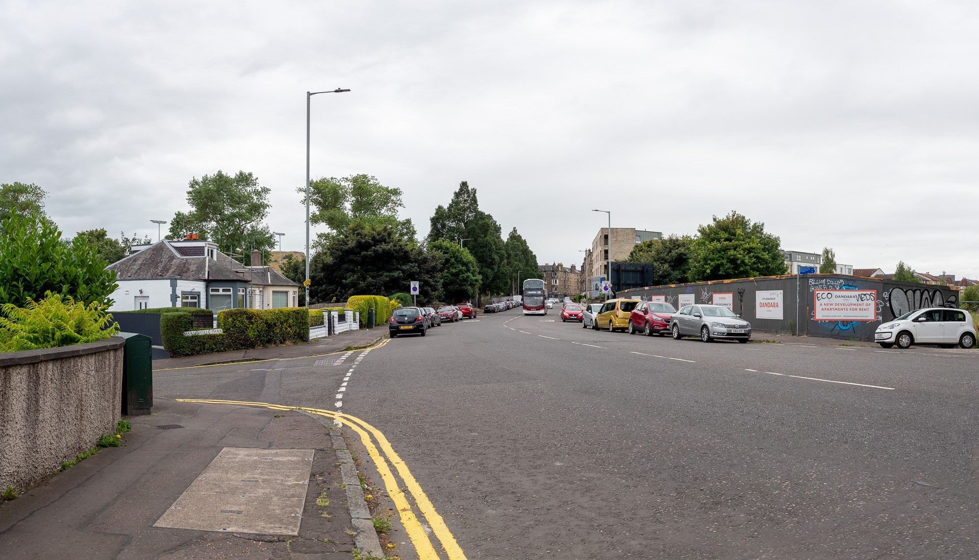
Accessible description of current view of Marionville Road
This image shows a photograph of the existing road layout at Marionville Road, looking west from Marionville Park. The road runs from the foreground into the distance, curving slightly to the right. Double yellow lines mark the edge of the road on the left side in the foreground. Cars are parked along both sides of the of the road. In the distance, a red double-decker bus is driving along the road, approaching the viewer. Buildings are visible on both sides of the street.
Proposed view of Marionville Road
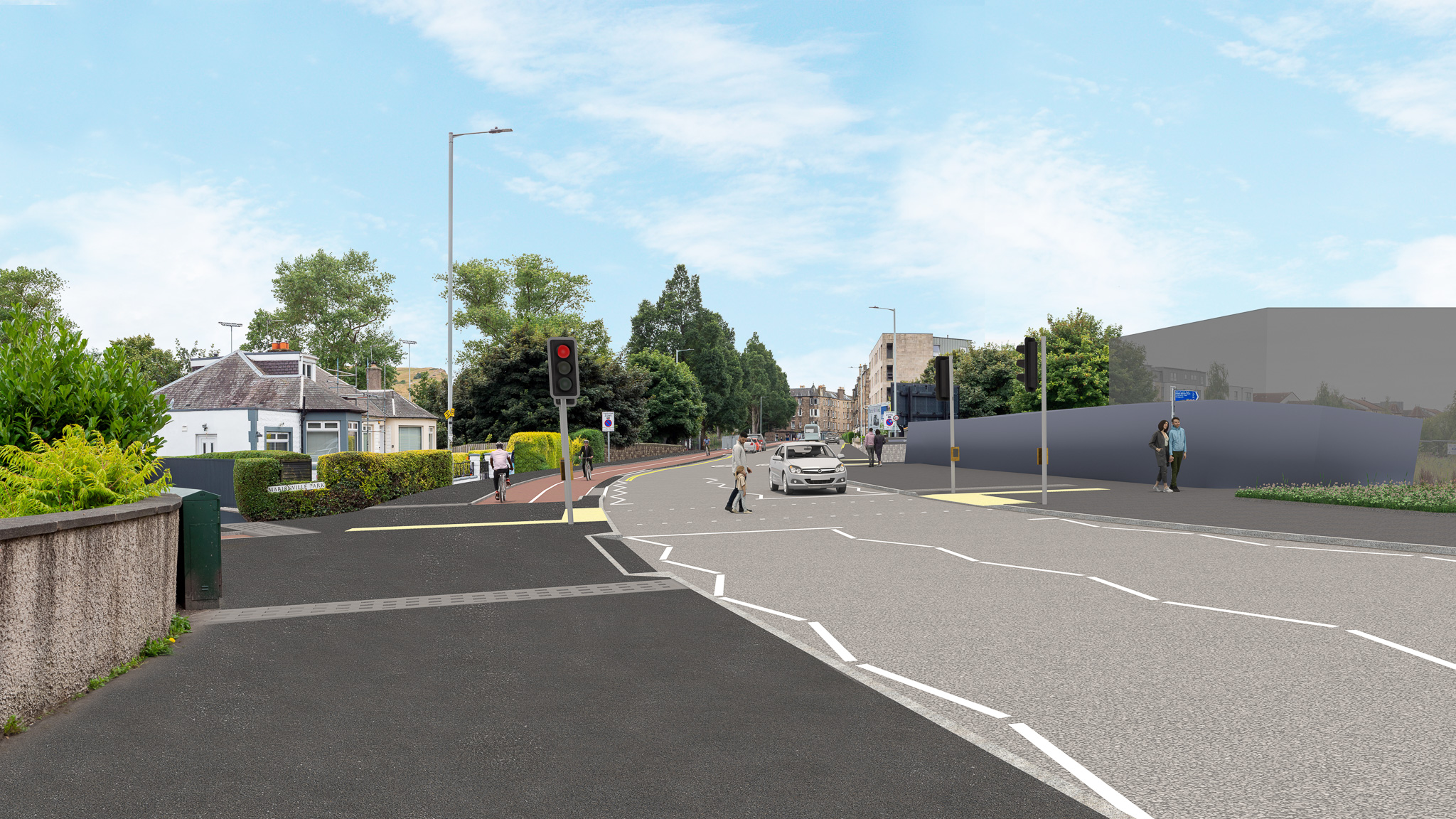
Accessible description of proposed view of Marionville Road
This image shows a street-level view of the proposed changes to Marionville Road, looking from the same vantage point as the previous photograph. A toucan crossing is shown in the foreground. The pavement has been widened on both sides of the road and the new two-way cycle track is visible beyond Marionville Park. The entrance to Marionville Park is shown as a continuous footway. People are shown walking on the pavements and crossing the road. A white car is stopped at the crossing, and buildings are visible on both sides of the street.
Why your views matter
Over recent years your feedback has helped shape and influence the development of the wider Meadowbank area. We would welcome your input and feedback on these proposals too.
Need a different language or format?
![]()
Please email the Interpretation and Translation Service at its@edinburgh.gov.uk quoting reference 25-0670 - Marionville Road.
Areas
- Ward 14 - Craigentinny/Duddingston
Audiences
- Residents
- Road users
- Services/utilities
- Transport groups
Interests
- Area regeneration
- Roads and pavements
Share
Share on Twitter Share on Facebook