
Leith Connections: Phase 3 west - east proposals
Feedback updated 12 Dec 2022
We asked
We asked for your views on proposals for Phase 3 of the Leith Connections project which would include high quality active travel and public realm improvements along the Lindsay Road to Salamander Street corridor between the Hawthornvale Path in the west and Seafield shared use path in the east. Previous feedback from public surveys, online workshops and meetings with relevant stakeholders highlighted this as an area with poor pedestrian and cycling facilities.
The proposal seeks to enhance a sense of place while improving provision for those walking, wheeling and cycling through features such as continuous footways, rain gardens, segregated cycling infrastructure, pocket parks and other place making features that are in keeping with the palette of the conservation setting. In addition, 3 new pedestrian crossings are proposed and 2 existing ones will be relocated to be closer to the desire line of pedestrians and cyclists.
To publicise the engagement we delivered leaflets throughout the area and emailed local stakeholder groups. We also promoted the opportunity to give feedback through social media and newspaper website articles. We held two drop in events in the area where proposals could be viewed and you could meet the project team.
You said
72-78% of respondents agreed with the proposed approach to improve walking, wheeling and cycling conditions in each of the six areas presented in the engagement. 67% of respondents said that the proposals would make them more likely to walk or wheel for short journeys. Strong levels of support were received for trees and other planting, seating and cycle parking in the Hawthornvale path and Bernard Street areas.
From feedback in the survey and at drop in events a number of other themes and comments have emerged including:
- suggestions to improve the design of the Lindsay Road junction to make it easier for cycles to make westbound turns from Ocean Drive
- concerns around the impact on public transport
- concerns over the effects of Leith Connections project as a whole may have on traffic congestion
- concerns over vehicle parking along the corridor were raised – including both objections and support for the reduction in on street vehicle parking, comments on the impact of current pavement parking and the need to protect the cycle track from illegal parking
- respondents requesting the addition of more continuous footways
We did
We have now produced a Final Concept Design. We are seeking further project funding to continue with the next stages of design and we will look to incorporate community feedback as the project moves through the next stages of design.
Results updated 12 Dec 2022
Files:
- Leith Connections Phase 3 Engagement Report, 2.9 MB (PDF document)
- Leith Connections Phase 3 Concept Design FINAL, 8.9 MB (PDF document)
Overview
The Leith Connections project is aiming to create a safer and more comfortable street environment for residents walking, wheeling, cycling and spending time in the local streets and outdoor spaces of Leith. The project builds upon the City of Edinburgh Council’s City Mobility Plan. This aims to help Edinburgh connect through a safer and more inclusive carbon neutral transport system - delivering a healthier, thriving, fairer and compact capital city and a higher quality of life for all residents.
Latest project updates on the project can be found on the Leith Connections page of the council website.
We have previously presented proposals and got feedback on:
- Phase 1 - high quality cycle track between Foot of the Walk and Ocean Terminal.
- Phase 2 - low traffic neighbourhood in the area by removing through traffic and allowing the creation of new community spaces. This will help to improve overall pedestrian and wheeling conditions across the area.
We are now seeking feedback for Phase 3 of the Leith Connections project:
- Phase 3 - high quality active travel and public realm improvements along the Lindsay Road to Salamander Street corridor between the Hawthornvale Path in the west and Seafield shared use path in the east.
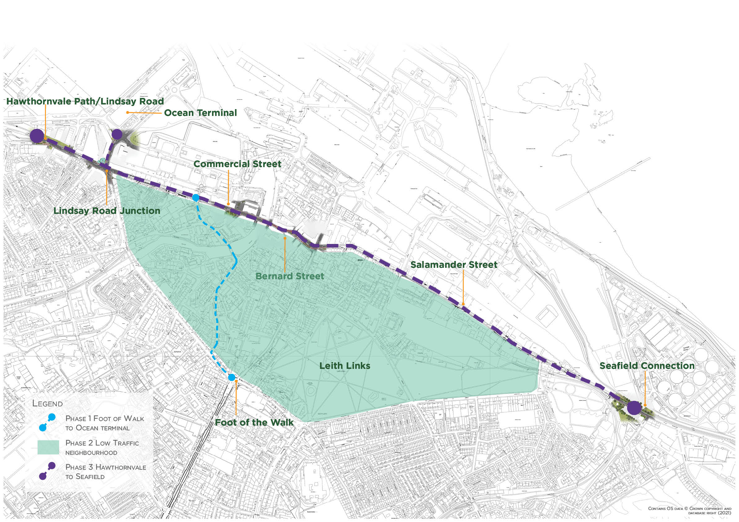
Overview map of Leith Connections project area and phases
Please see Events section below for our drop in events where you can see our proposals and speak to members of the project team.
Local Development Plan
The Local Development Plan (LDP) has identified significant areas of new residential development in the Leith area. An action programme has been developed to look at what improvements are needed to existing infrastructure and what new infrastructure is needed to provide safe and high-quality routes to enable more people to travel in sustainable ways. Proposals presented here will contribute to the delivery of this action programme.
Previous engagement feedback
The following document outlines previous feedback from the Commercial Street and Salamander Street corridor (gained through public surveys, online workshops and meetings with relevant stakeholders in the first half of 2021) which was highlighted as an area with poor pedestrian and cycling facilities.
Since the two periods of community engagement in 2021, the following engagement activities have been taking place:
- Ongoing contact with the Coalie Park Project and Leith Links Masterplan to tie up proposals where appropriate.
- Meetings with Friends of Water of Leith Basin and members of the local rotary on site.
- School session with St Mary’s RC Primary School and planning the same for Leith Primary School.
- Meetings with Community Councils.
- Updates to Emergency Services.
- Updates to Lothian Buses.
An example of the materials produced by pupils of St Mary’s RC Primary School is presented below.
Why your views matter
Recent research in Edinburgh has shown that 66% of residents make trips by walking at least five days a week and 26% per cent of residents cycle at least once a week. The research also shows what residents feel needs to be done to improve conditions to enable even more people to travel by foot, wheel or bike, particularly for shorter journeys.
We would encourage you to complete this survey to help us to understand your travel needs and how best to support them through our proposals. We are at an early stage of development of proposals so are keen to hear from as many voices in the community as possible.
This survey should take around 15 minutes to complete and we are looking to get feedback on key design and placemaking proposals.
Events
-
Leith Connections Drop In
From 25 Jun 2022 at 10:00 to 25 Jun 2022 at 15:00Come and meet the project team and find out more information at Leith Market, Dock Place EH6 6LU
-
Leith Connections Drop In
From 14 Jul 2022 at 14:00 to 14 Jul 2022 at 18:00Come and meet the project team and find out more information at Duncan Place Community & Enterprise Hub EH6 8HW
Areas
- Natural neighbourhood area - Leith
- Natural neighbourhood area - Leith Links
- Natural neighbourhood area - Leith/Easter Rd
- Ward 12 - Leith Walk
- Ward 13 - Leith
Audiences
- Amenity groups
- Architects/designers
- Built heritage groups
- Businesses
- Carers
- Children & Young People
- Civil and public servants
- Community councils
- Developers/investors
- Development management statutory consultees
- Development planning key agencies
- Education institutions
- Elected Members
- Employees
- External councils
- Homeless People
- Housing associations
- Jobseekers
- Landowners
- Lesbian, gay, bisexual people, Transgender people (LGBT)
- Libraries
- Licence applicants
- Licence holders
- Low income households
- Men
- Minority Ethnic groups
- Natural heritage/open space
- Neighbourhood partnerships
- Older people
- Parents/carers
- People with disabilities
- People with long term conditions
- Planning consultants
- Professional bodies
- Professionals
- Residents
- Road users
- Scottish Government departments
- Services/utilities
- Students
- Taxi Licence holders
- Teaching/Educational staff
- Transport groups
- Visitors
- Voluntary sector/volunteers
- Women
- Young people
Interests
- Area regeneration
- Biodiversity
- Cycling and walking
- Enforcement
- Landscape designations
- Local plans and guidelines
- Nature
- Parks and green spaces
- Permissions for development
- Planning applications
- Pollution
- Public space
- Public Transport
- Road safety
- Roads and pavements
- Traffic regulation
- Trams
- Travel in Edinburgh
Share
Share on Twitter Share on Facebook