Roseburn to Leith Walk cycle link and street improvements
Results updated 13 Jul 2016
Files:
- RtoLW - Consultation Report Issue v3 Revised.pdf, 7.1 MB (PDF document)
Overview
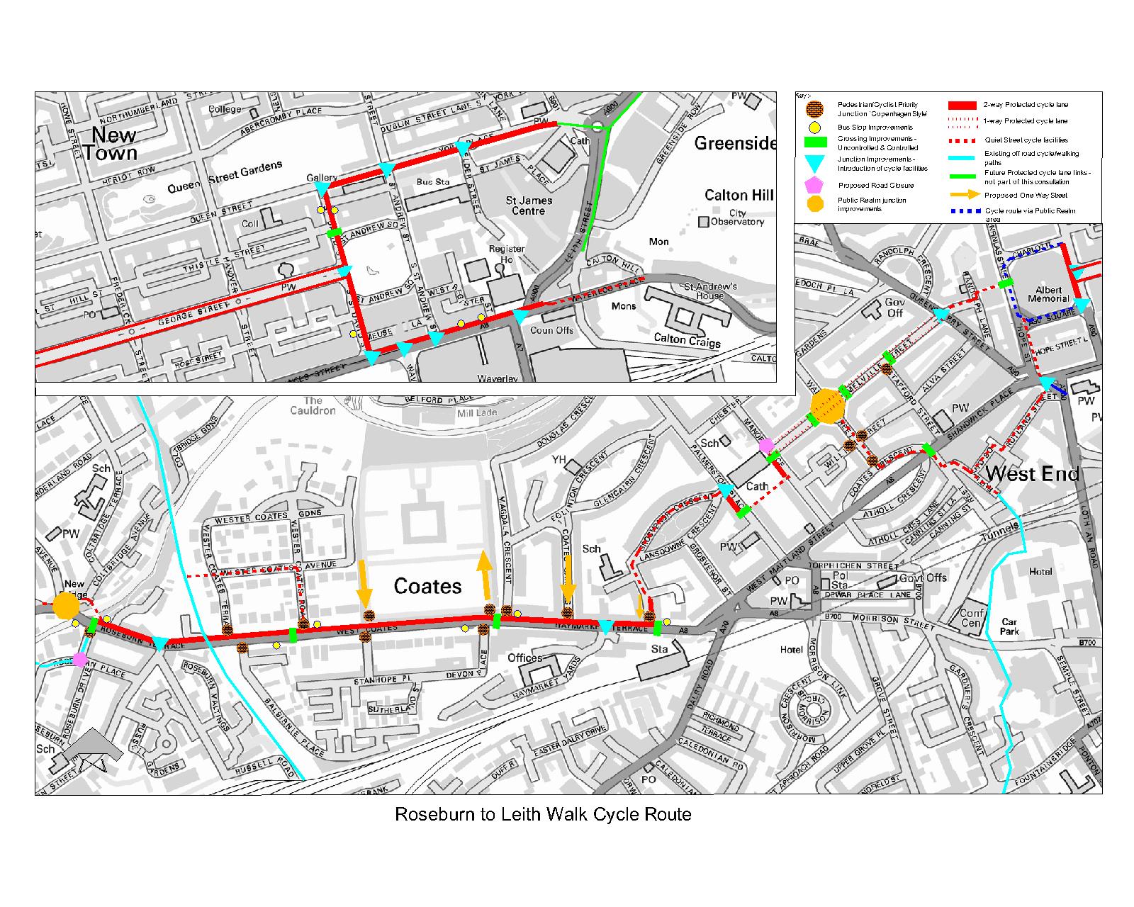
We want to hear your views on our proposals for a new cycle route linking west to east across the city centre and on the associated street improvements. This project would transform the quality of access by bike, providing a high quality route with protected cycle lanes on main streets. It would also improve the street environment for other road users, especially pedestrians.
With over 45,000 trips by bike made in Edinburgh every day, cycling is an increasingly popular way to get around the city.
The Council wants to help even more people get around by bike as part of its strategy of encouraging healthy and sustainable travel. In order to do this it is working to create a city-wide network of ‘QuietRoutes’ using off-road paths, low-traffic streets and protected cycle lanes on busier roads. These routes will aim to provide a pleasant and welcoming environment for all users.
The proposed cycle route would link with similar planned facilities on Leith Walk and Leith St to the east. At Roseburn it would connect with the extensive network of off-road paths in north Edinburgh and to routes west to South Gyle and Edinburgh Park. It would run through the heart of the city, connecting to Haymarket Station, Queensferry Street, Lothian Road, George St and North Bridge.
So what are the proposed improvements?
They include:
- Protected cycle lanes on main roads (e.g. West Coates)
- Cyclist and pedestrian priority at side roads to reduce conflict with other traffic
- New and modified crossings of main roads to help people travelling by bike or on foot cross conveniently and safely
- Some ‘traffic calming’ and other measures to make the street environment more pleasant for walking and cycling on quieter streets (e.g. Roseburn Place, Governor Crescent);
- Resurfacing of Randolph Place to make it more comfortable for cycling.
These improvements are being carefully integrated into major public realm works already underway and planned at St Andrew Square, Charlotte Square and George Street.
In developing the proposals we have already had some valuable input and feedback from Community Councils, cycling and pedestrian groups and transport operators. Now we are hoping to get views and contributions from as many people and organisations as possible.
Have your say
We very much want your feedback on the draft proposals. Please give us your views by completing the online survey by Monday 1 February 2016 or email us at cyclingprojects.consultation@edinburgh.gov.uk.
Details of our proposals
Further information regarding the proposals include;
|
Murrayfield Gardens |
|
|
Murrayfield Avenue |
|
|
Murrayfield Place |
|
|
Old Colt Bridge |
|
|
Roseburn Place |
|
|
Roseburn Gardens |
|
|
Roseburn Terrace |
|
|
West Coates |
|
|
Haymarket Terrace |
|
|
Coates Gardens |
|
|
Rosebery Crescent |
|
|
Coates Gardens |
|
|
Rosebery Crescent |
|
|
Grosvenor & Lansdowne Crescent |
|
|
Palmerston Place |
|
|
Bishops Walk |
|
|
Manor Place |
|
|
Melville Street |
|
|
Walker Street |
|
|
Coates Crescent |
|
|
Canning Street |
|
|
Rutland Square |
|
|
Queensferry Street |
|
|
Randolph Place |
|
|
Charlotte Square |
|
|
Hope Street to Lothian Road |
|
|
George Street |
|
|
St Andrews Square |
|
|
North St David Street |
|
|
York Place |
|
|
South St David Street |
|
|
Princes Street |
|
|
Waterloo Place |
|
What happens next
A summary of the consultation results will be published on this page in January 2016. The feedback received will be analysed and considered by the project team and used to decide on changes made to the preferred design.
Where possible, we will try to incorporate people’s suggestions however where this is not possible reasons will be provided.
A summary of the results for everyone who took part will be produced and will say how suggestions made by the public have been used.
We will return to the Transport & Environment Committee for approval to commence with the final detailed design of the scheme and the legal processes necessary to implement the changes.
This will then give any interested parties the right to formally object or express other views.
Events
-
Drop in Session - Roseburn Primary School
From 18 Jan 2016 at 16:00 to 18 Jan 2016 at 20:00Roseburn Primary School
64 Roseburn Street
Edinburgh
EH12 5PL
Areas
- All Areas
Audiences
- Amenity groups
- Architects/designers
- Built heritage groups
- Businesses
- Carers
- Children & Young People
- Civil and public servants
- Community councils
- Developers/investors
- Development management statutory consultees
- Development planning key agencies
- Education institutions
- Elected Members
- External councils
- Homeless People
- Housing associations
- Jobseekers
- Landowners
- Lesbian, gay, bisexual people, Transgender people (LGBT)
- Libraries
- Licence holders
- Low income households
- Men
- Minority Ethnic groups
- Natural heritage/open space
- Neighbourhood partnerships
- Older people
- Parents/carers
- People with disabilities
- People with long term conditions
- Planning consultants
- Professional bodies
- Professionals
- Residents
- Road users
- Scottish Government departments
- Services/utilities
- Students
- Taxi Licence holders
- Teaching/Educational staff
- Transport groups
- Visitors
- Voluntary sector/volunteers
- Women
- Young people
Interests
- Cycling and walking
- Park and ride
- Parking permits
- Parking spaces
- Parking tickets
- Public Transport
- Road safety
- Roads and pavements
- Traffic regulation
- Trams
- Travel in Edinburgh
Share
Share on Twitter Share on Facebook